The INTERNATIONAL GEOGRAPHY OLYMPIAD (iGeo)

What is iGeo?
The Next iGeo
Previous iGeos &
past questions
Test Guidelines
Statutes
National Competitions
What is geography?
Sponsors
Alumni
Contact
Sueguides@hotmail.co.uk

Website contact: smshen@ntnu.edu.tw
The 2000 iGeo - Seoul, South Korea
"Seoul by night"
This report is a record of the experience and a collection of materials of the third International Geography Competition held from the 13th to 19th of August 2000 in Seoul, Korea. The Competition is a unique program of the IGC that has been prepared especially for futures young geographers. The Competition had two goals: to promote international awareness for High School Students through social contacts and interaction, and to contribute to the study of Geography at Secondary Schools. We hope many geographers share the experience of the Competition and contribute to geography education in their country.
Compared with the long history of the IGU, which had its 29th Congress in Seoul, the competition has a relatively short history. It had only its third competition. Some countries have had their National Olympiad of Geography for much longer. However, it was at the Regional Congress in Prague in 1994 when the idea of having a standing international geography competition program was first discussed in earnest by the IGU President and several members of the Commission on Geographical Education. As a result, the first International Geography Competition was held in 1996 in Hague, the second in 1998 in Lisbon, and the third in 2000 in Seoul.
The Seoul Competition was a great success and opened new possibilities for the internationalization of the program. The number of participating countries in the competition was twice that of previous competitions. Although the increase of participants caused many difficulties in preparing for and operation of the Competition, all participants were satisfied with the organization of the program. Three kinds of test and 11 events of ceremonies and social programs were executed during the competition week.
The competition should be developed into a better format. Although the Seoul competition showed a possibility of the satisfactory format it was yet in challenging and experimental stage. Such matters as financial difficulties and institutionalization of the program need much endeavor and should be solved. It is expected that the International Geography Competition program will continue as an important tradition of IGU academic activities. The organizers hope the experience of Seoul Competition would provide a new road map in the years to come.
The success of the Seoul Competition owed much to the devotion and support of many persons and organizations. For one and half years, all the members of the Organizing Committee poured themselves , into preparing for the competition. It was not an easy task; however, all of us feel it was worthwhile both for ourselves and for the future of geography. We enjoyed working on it. Closing the event, we would like to extend our sincere gratitude to all who assisted us with this program.
Dooil Kim, Chuisue Hwang, Woo-ik Yu
Full List of Participants
Tests
The core of the competition lies with the test, and there was a great endeavor allocated to the law development of questions. Following the Statutes of the Competition the level of test was set around on the curriculum of secondary school. The Seoul competition took the same format as the two previous competitions: a written test, a fieldwork assignment, and a quiz, although contents were different to some degree. Committees made questions, corrected, and graded.
The large number of participating countries required various considerations in developing questions. The most complicated and challenging task was to develope questions that will do justice to different geography curricula in the participating countries. Test committees selected two introductory levels of geography books and Geography of Korea as the texts for the competition and informed the participating countries of these decisions. Another problem was to decide to what extent the Congress Theme would be reflected on the questions. The first and second competitions gave a lot of emphasis on Congress Themes. Three committees in charge of developing questions discussed what should be the general direction of the questions at length and decided to test participants general knowledge of geography. The decision was made considering the increased number of participating countries. The committees also decided that English and French will be the official languages of the competition, the same with IGC and prepared all the competition-related materials in the two languages. However, to minimize language problems and to evaluate the abilities applying geographic techniques, many maps and pictures were included in the problem set.
Language dictionaries were permitted in class. Leaders were allowed to stay in class, at the rear part of the classroom, during the exam hours for a moment. At fieldwork each leader was assigned to a team of the other country and accompanied those students for whole day. So leaders or observers were physically separated from their students during the test hours.
Committee members, some leaders, and several American and Australian geographers of the CGE participated in grading. Basically each answer sheet was reviewed by three persons and were scored as the average of the grades given by three persons. In order to insure fairness, leaders did not grade the papers of the students in their own country.
The ratio of each field in geography, physical, human and technical aspects, was 37, 58 and 4, respectively. Maps, figures or diagrams were provided with most questions in order to help understanding text of each question.
The written test covered a broad spectrum of geography. It consisted of 18 questions in 8 fields: the extension of Trans-Siberian railroad, population pyramids, changes in manufacturing employment, the location of nuclear power plants, urban climate, images of the world, formation of mushroom rock and a climate graph. The ratio of physical geography to human geography was 37 to 63. Two hours were allocated for the written test from 10:00 to 12:00 on August 15. The written test comprised 50% of the total score.
Questions for the fieldwork assignment were divided into two parts: Kwanghwamun and Samsung-dong part was on the human aspects of geography and the Amsa-dong part was on the physical aspects. All three sites selected are within the Seoul City limits. Kwanghwamun is an old downtown area of Seoul, which has very old streets in its vicinity while Samsung-dong is a newly developed sub-center. In contrast, Amsa-dong is the natural levee of the Han River and the site of a prehistoric settlement.
One day, August 16, was allocated for a fieldwork excursion. Each team consisted of three students from the same country, one leader from a different country, and one Korean student whose responsibility was to show the way to an assigned fieldwork site and answer non-geographical questions. At each site there were college professors who guided teams along the planned routes. The weather forecast called for rain in the afternoon of the excursion day but it was only cloudy throughout the day. Two large buses were rented for the transportation of the teams.
There were a total of 11 questions: 7 about Kwanghwamun and Samsung-dong and 4 about Amsa-dong, thus the ratio of physical to human aspects of questions was 40 to 60. Thirty percents of total scores were allocated to the fieldwork assignment.
Quiz was the third part of the test. The quiz consisted of 40 questions. This made up 20% of the total test score. The ratio of physical, human and technical aspects of geography was 37%, 45%, and 18%, respectively. Of the three types of test, a quiz contest covered a wide scope of geographical knowledge. Most questions had maps, diagram, or figures. Students were asked to choose appropriate answers or write down appropriate words or short phrases. Answering time limit was 90 seconds per question.
Maps or diagrams were used because they had been basic techniques in geography. An experienced quiz master, Professor Young-in Moon, University of Seoul, read or explained the text in English and the text and the maps, diagrams or figures were projected on separate screens by beam projectors.
Download the:
Multimedia Test Example Question
Results
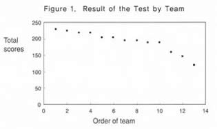
The result of the competition is shown on the Table 1. The average level of achievement was 65.3 percent and similar to that of the Hague, 65.1 percent, which meant that the difficulty of the tests was similar to the two previous competitions. Fieldwork assignment was relatively easier than the other two tests in the competition. The order of teams by total scores shows smooth pattern as shown on the Figure 1.
The average level of achievement in written test was 62.7%. The relative scores in the questions of nos. 6 and 8 were high and those of nos. 7, 11 and 18 were low. In the questions of nos. 11, 15, 16 and 18, variation of scores was relatively wide.
The average level of achievement in fieldwork assignment was 70.9 percents. Students got high percentages in the questions of nos. 2, 3, and 4 of worksheet-2 in Kwanghwamun and Samsung-dong part and low scores in nos. 1 and 4 in Amsa-dong part. The questions of nos. 2 and 4 in Amsa-dong part were high in the coefficients of variation.
The average level of achievement in quiz was 63.5 percents.
First prize was awarded to Adam Biliski from Poland, by Bruno Messerli, the IGU President, second prize to Ho Seok Lee from Korea, and the third to Magdalena Bieroza from Poland. In the area of the written test, Ho Seok Lee from Korea topped the list and the Poland team won the best award in the fieldwork assignment. The best award for the quiz went to Adam Biliski from Poland. In terms of total score, Poland team topped the list followed by the Netherlands and Korea. Small souvenirs were given with certificates.
There were two characteristics in the pattern of the result in the Seoul Competition. First, the European countries were strong in the test. The reasons for the high performance may be, interests in geography in secondary school education, nation-wide preparation for the international competition, past experience of competitions in the two previous competitions. Among newly participating countries only Korea had good results. Second, Poland was the best team in this competition as well as in the two previous competitions. Poland had the record of the best team in the three consecutive competitions although the margin to the Netherlands team was very narrow in Seoul Competition. Seamless preparations for the competition, geographical curriculum in their secondary school, strong tradition in geographic thought in nation, and obligatory feeling that they must maintain their tradition of winning in the first and second competitions, might be the factors for such an exceptional performance. The case of Poland gives us some lessons as to what we should do to promote stellar image of geography within our nation.